Laser Design Inc

952-252-3479

Menu
  • Home
  • Products
      • 3D Scanners
          • Portable 3D Scanners
            • Portable 3D Scanners

              Portable Scanners are the ideal option to quickly scan complex shapes and geometric data from objects large or small when you want to go anywhere and inspect anything.

              Portable Scanners >

            • Close
          • Desktop 3D Scanner
            • Desktop Scanner

              Desktop Scanners are the ideal option to quickly scan complex shapes and geometric data from small objects.

              Desktop Scanner >

            • Close
          • Long-Range Scanner
            • Long-Range Scanner

              3D portable scanner that capture precise dimensions of large objects such as wind turbines, ship propellers, airplanes and buildings. Producing 3D scans of the highest quality.

              Long-Range Scanner >

            • Close
          • CT (X-ray) Scanners
            • CT (X-ray) Scanners

              Capture all geometry, both external and internal, of complex and free-form parts.

              CT Scanning Systems make non-destructive evaluation possible.

              CT Systems >

            • Close
          • Metrology Grade Scanners
            • Metrology Grade Scanners

              Need to capture ultra-precise surface data for reverse engineering and inspection?

              3D laser scanning with our high precision scanners are a great solution.

              Metrology Grade Scanners >

            • Close
          • Body Scanners
            • Body Scanners

              3D human body scanners obtain 3D images and models in seconds, making this an ideal solution for full body digitizing and human body modeling.

              3D Body Scanners >

            • Close
        • Close
      • Software & Accessories
          • 3D Anti-Glare Spray
            • 3D Anti-Glare Spray

              To achieve optimal accuracy and results with 3D laser scanning it is often necessary to apply an anti-reflection coating. Helling 3D Scan Spray is especially designed for this purpose.

              3D Scan Spray>

            • Close
          • Artec Studio
            • Artec Studio

              Industry acclaimed software for professional 3D scanning and data processing.

              Artec Studio>

            • Close
          • InnovMetric-Polyworks Software
            • InnovMetric-Polyworks Software

              PolyWorks is a powerful industrial 3D metrology software solution.

              Polyworks Software>

            • Close
          • Geomagic Software
            • Geomagic Software

              Geomagic software offers products for 3D digital realities.

              Geomagic Software>

            • Close
          • SpaceClaim Software
            • SpaceClaim Software

              SpaceClaim empowers engineers to be more creative and deliver products to market faster.

              SpaceClaim Software >

            • Close
          • Volume Graphics Software
            • Volume Graphics Software

              Volume Graphics offers a range of products for the visualization and analysis of CT data and has become a virtual standard for industrial voxel data analysis.

              VG Software >

            • Close
          • ExactFlat Software
            • ExactFlat Software

              ExactFlat enables manufacturers to design, flatten, conduct pattern engineering, nest, cost and create manufacturing and business documentation all on one platform.

              ExactFlat>

            • Close
        • Close
    • Close
  • Services
      • 3D Scanning
          • Parts & Objects
            • 3D Scanning - Parts & Objects

              3D scanning converts physical objects into precise digital models, enabling you to quickly and accurately capture your object’s shape and geometries.

              3D Scanning>

            • Close
          • Buildings & Structures (BIM)
            • 3D Scanning - Buildings & Structures

              Terrestrial 3D scanning is a ground-based technique for collecting high-density spatial imaging with millions of coordinates quickly and accurately.

              Buildings & Structures (BIM)>

            • Close
          • Aircraft, Vehicles & Large Objects
            • Aircraft, Vehicles & Other Large Objects

              Terrestrial & Mobile 3D scanning are techniques for collecting high-density spatial imaging with millions of coordinates quickly and accurately for your aircraft, vehicles and vessels.

              Large Object 3D Scanning>

            • Close
          • ITAR – Weapons
            • ITAR - Weapons

              Laser Design is committed to investing in secure resources that ensure that all of our ITAR data is stored in a manner that meets or exceeds the ITAR requirements. With Laser Design you know your ITAR project is not only compliant but being fulfilled by a company that is registered.

              ITAR - Weapons>

            • Close
          • Industrial CT Scanning
            • Industrial CT Scanning

              Metrology grade Computed Tomography (CT) inspection allows a complete 3D capture of complex internal geometry of parts without needing visual access – the process is nondestructive.

              CT Scanning>

            • Close
          • Reverse Engineering
            • Reverse Engineering

              Reverse engineering using 3D scan data is the most efficient way to generate a CAD model from a physical object that has any kind of complex or freeform shape.

              Reverse Engineering>

            • Close
          • Inspection & Metrology
            • Inspection & Metrology

              Helping to solve your most demanding dimensional inspection issues, digitizing, calibration, certification and all other facets of manufacturing that have to do with 3D metrology.

              Inspection & Metrology>

            • Close
        • Close
      • Point Cloud Modeling
        • Point Cloud Modeling

          If you have a scanner but would like help taking your point clouds to CAD format then let the 3D experts help! Everything from small plastic parts, blades to entire ships and buildings.

          Point Cloud Modeling>

        • Close
      • Scanner Rentals
        • Scanner Rentals

          Laser Design’s knowledgeable rental staff has actual project experience with the 3D equipment we provide.

          Scanner Rentals>

        • Close
      • 3D Photorealistic Rendering
        • 3D Photorealistic Rendering

          Moving from 2D to 3D improves how your ideas and concepts are shown and communicated. When you’re able to show your designs in 3D verses a static 2D drawing the experience is more realistic.

          3D Photorealistic Rendering>

        • Close
    • Close
  • Solutions
      • Industries
          • Aerospace
          • Anthropology
          • Architecture, Engineering, Construction
          • Automotive
          • Bridge
          • Consumer Electronics
          • Defense
          • Education
          • Entertainment
          • Forensics
          • Foundry
          • Heavy Machinery
          • Heritage
          • Hydro Power
          • Law Enforcement
          • Legal
          • Machine Shop
          • Marine
          • Medical
          • Mining
          • Oil & Gas
          • Online Retail
          • Orthotics and Prosthetics
          • Petrochemical
          • Plastics
          • Power Generation
          • Tunnels
          • Wind Power
        • Close
      • Applications
          • 2D to 3D CAD Conversion
          • Accident Reconstruction
          • Alignment
          • As-Built Documentation
          • Asset and Facility Management
          • Body Scanning Application
          • CAD-Based Inspection
          • Class A Surfacing
          • CGI and Visual Effects
          • Contract Inspection
          • Computer Aided Verification
          • Crime Scene Analysis
          • Dimensional Analysis
          • Electronic Site Survey
          • Emergency Response Scanning
          • FEA – Finite Element Analysis
          • First Article Inspection
          • Form Analysis
          • Gear Inspection
          • Incoming Inspection
          • In-Process Inspection
          • Large Part Inspection
          • Litigation Support
          • Machine Calibration
          • Non-Contact Inspection
          • Photorealistic Modeling
          • Product Design
          • Reverse Engineering
          • Robot Calibration
          • Scene Documentation
          • Tool Building and Setup
          • Virtual Simulation
        • Close
    • Close
  • About Us
    • About Laser Design
    • Why Choose Laser Design?
    • Customer Testimonials
    • 3D Technologies Used
    • Careers
    • Partner Programs
    • Terms and Conditions
    • Contact Us
    • Locations
    • Close
  • Locations
    • United States Locations
    • Close
  • Learning Portal
    • Sample Files
    • Blog
    • Case Studies
    • News
    • Videos
    • What is 3D Scanning?
    • 3D Technology Glossary
    • ROI of 3D Scanning
    • Close
  • Contact Us

Laser Scanning Inaccessible Areas

June 15, 2020 by Laser Design

leica-powerline
Given the level of sophistication that technology has achieved in the 21st century, you would think that the architecture, engineering, and construction (AEC) industry would have already adopted an advanced solution across the board for projects involving inaccessible areas, such as wind turbines and telecommunication structures—but this isn’t the case. Traditional measuring methods require technicians to scale structures hundreds of feet tall, which creates challenges for both safety and efficiency. Fortunately, a solution does exist, and it’s growing in popularity.

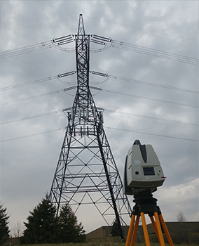
3D terrestrial laser scanning can be used to capture an enormous amount of data in traditionally inaccessible places. This is particularly useful for projects involving very tall objects like high voltage transmission towers, cell phone towers, and wind turbines. Overall, the efficiency and accuracy provided by terrestrial laser scanning result in significant project savings in terms of time and money with this safer method.

How 3D Laser Scanning Can Streamline Your Workflow 

Terrestrial laser scanners like the Artec Ray use powerful laser technology to quickly generate digital representations of objects and structures. Laser light makes it possible to scan over long distances in outdoor conditions, meaning that it’s possible to capture scan data anywhere, at any time. And, thanks to this technology, project timelines are no longer dictated by the size of the structure that needs to be measured. 

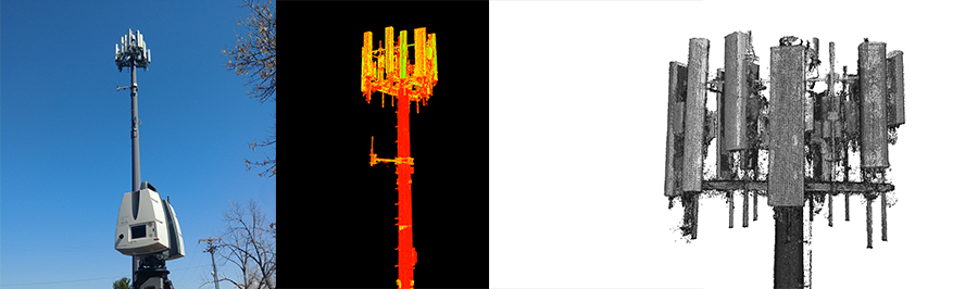
The result? Millions of XYZ points, or “point cloud” data, that can be modeled and manipulated for use across teams. You might think of terrestrial 3D scanning as the most direct route to acquiring the data you need to get the job done. 

What Can 3D Scan Data Be Used For?

The data generated during the 3D laser scanning process can be delivered in a number of file formats and used for multiple purposes, including the following:

  • Structural analysis
  • CAD modeling
  • BIM integration
  • Reverse engineering
  • Evaluating maintenance needs
  • Inspecting potential implementation sites
  • As-built documentation
  • Elevation drawings

When it comes to very large structures like telecommunication towers and wind turbines, terrestrial scanning proves useful for both installation and maintenance projects. Whether you’re evaluating the integrity of a potential installation site for a cellphone tower or working to evaluate damage to an inoperable wind turbine, the point cloud data generated by a 3D scan will allow you to accomplish your task quickly, efficiently, and safely.

cell_tower_data

4 Benefits of Terrestrial Laser Scanning for Inaccessible Areas

Let’s take a closer look at the value that terrestrial 3D scanning can add to a project.

1. Accuracy

Traditional measurement methods may risk the safety of team members, particularly on projects involving massive structures like wind turbines. But on top of that, those traditional methods aren’t foolproof. Terrestrial 3D scanning captures very complete and accurate measurement data that far surpasses what is provided by traditional measurement methods, whether you’re scanning complex mechanical rooms or exterior structures. This increased accuracy eliminates revisits for the measurement team. Once data has been captured, it can be used to create highly accurate CAD models for documentation and future design efforts.
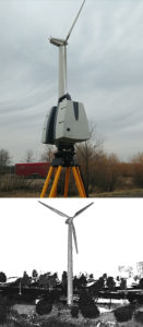
2. Efficiency

Another advantage of terrestrial 3D scanning is that elevated areas can be measured very quickly and completely. The technology can be used to capture millions of measurement points of steel and composite structures, turbine vane alignment, mounting fixtures, positions of transmission equipment, antennas, and more. And, as we mentioned, the accuracy of 3D laser scanning reduces rework stemming from faulty documentation, saving hundreds of hours in planning time and misspent labor.

3. Safer Conditions

You simply can’t put a price on safety. Where traditional measuring methods have technicians climbing hundreds of feet to measure large structures, 3D scanning can be performed from the ground—and even a significant distance away from the structure in question. This adds an invaluable increase in safety and a decrease in liability to a project.

4. Lower Costs

Lastly, terrestrial 3D scanning eliminates field modification of new equipment by identifying interference potentials before installation, leading to faster project completion time and reduced expense. This can allow you to come in under budget and complete work before a deadline, potentially earning early completion bonuses. This added efficiency will allow you to win more projects with leaner processes, leading to a lower end cost for you and any customers you may have.

3D Laser Scanning Units and Services From Laser Design

Terrestrial laser scanning represents a significant opportunity to cut down on project costs and shorten completion time. We’re here to help you reap the many benefits of this powerful technology. Laser Design, a CyberOptics Corporation brand, has been providing high-quality 3D scanning services and 3D scanners to a variety of customers throughout the AEC industry for over 30 years. 

Whether you’re installing a high-voltage transmission tower, engineering a new design in Revit, or analyzing structural performance with Finite Element Analysis, our talented team will work with you to identify the right 3D solution that will streamline your project. Contact us today to learn more about our 3D scanning services bureau or purchasing your own scanner.

Filed Under: Blog

About Laser Design

Laser Design, a CyberOptics Corporation Brand, has been a leading supplier of 3D scanning systems and services since 1987. Laser Design helps customers successfully solve their most complex 3D inspection, analysis, and reverse engineering challenges quickly, giving them a competitive advantage.

Whether the 3D solution needed is a new 3D scanner or a service project performed in our lab or at your site – Laser Design’s expert metrologists and experienced engineers have you covered – on your schedule, within your budget and with ultra accuracy & results our customers have come to expect.

  • Learning Portal
    • Sample Files
    • Blog
    • Case Studies
    • News
    • Videos
    • What is 3D Scanning?
    • 3D Technology Glossary
    • ROI of 3D Scanning
ldi-exp_246-254

What Customers are Saying…

toro“The process was very successful for us, by using the scan data, the engineers were able to correct the problem quickly and accurately." -N.F. @ Toro

Question about 3D Scanning?

Ask a 3D Expert>>

Sign-up for our eNews:

Email Signup

  • Facebook
  • Twitter
  • YouTube
  • LinkedIn
  • Videos
  • eNews
Sign-up For Our Newsletter
PRODUCTS
  • 3D Scanners
    • Portable 3D Scanners
    • Desktop 3D Scanner
    • CT (X-ray) Scanners
    • Metrology Grade Scanners
    • Body Scanners
    • 3D Scanners for CMMs
  • Software & Accessories
    • 3D Anti-Glare Spray
    • Artec Studio
    • InnovMetric-Polyworks Software
    • Geomagic Software
    • Space Claim Software
    • Volume Graphics Software
    • ExactFlat Software
SERVICES
  • 3D Scanning
    • Parts & Objects
    • Buildings & Structures (BIM)
    • Aircraft, Vehicles & Large Objects
    • ITAR – Weapons
    • Industrial CT Scanning
    • Reverse Engineering
    • Inspection & Metrology
  • Point Cloud Modeling
  • 3D Photorealistic Rendering
  • View all services »

Solutions
Industries
Applications

About Us

Learning Portal

Contact Us
Laser Design
5900 Golden Hills Drive
Minneapolis, MN 55416

All Locations

Terms of Use | Privacy Policy | Contact Us | 952-884-9648

© 2025 CyberOptics Corporation. All Rights Reserved.

This website uses cookies to improve your experience. We'll assume you're ok with this, but you can opt-out if you wish. Cookie SettingsACCEPT
Privacy & Cookies Policy

Privacy Overview

This website uses cookies to improve your experience while you navigate through the website. Out of these cookies, the cookies that are categorized as necessary are stored on your browser as they are essential for the working of basic functionalities...
Necessary
Always Enabled
Necessary cookies are absolutely essential for the website to function properly. This category only includes cookies that ensures basic functionalities and security features of the website. These cookies do not store any personal information.
SAVE & ACCEPT

Notifications